July 2008
After a big snow winter, it'll be a while until the snow melts out at higher elevations. Even the top of this route could have snow until mid-July this year. But most of this amoeba loop is open. (And you can easily skip the leg up to the high point.) And it has one of the best descents anywhere. Read on.
The Scoop
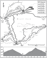
At 27 miles, this loop doesn’t quite achieve epic 5-wheel status. But be afraid, be very afraid. The ride’s three long, tough climbs add up, and you’ll have wished you’d done a few more training rides before the day is over. The reward, however, is a couple of the best descents in the book—packaged together in one ride. They’ll put a smile on even the most over-tired, curmudgeonly rider. For reference, this route includes parts of High Prairie (ride 9), Fivemile Butte (ride 7), and the entire length of Fifteenmile Creek (ride 10).
Driving Directions
From Portland, take US Highway 26 eastbound about 56 miles, past Ski Bowl and Government Camp, to its junction with State Highway 35. Turn north onto Hwy 35, and proceed about 13 miles to Forest Road 44, which is past milepost 70. Turn right onto FR 44, and zero out your odometer. At 5.5 miles, bear right to remain on FR 44. At 8.9 miles, pass FR 4420 on your right. At 10.4 miles, turn left on FR 4430, toward Eightmile Crossing Campground. At 10.7 miles, turn right into the campground. Park in the day-use area.
From Hood River (exit 64 off Interstate 84), drive south on Hwy 35. After about 27 miles, just after passing milepost 71, turn left onto FR 44 and set your odometer to zero. At 5.5 miles, bear right to remain on FR 44. At 8.9 miles, pass FR 4420 on your right. At 10.4 miles, turn left on FR 4430, toward Eightmile Crossing Campground. At 10.7 miles, turn right into the campground. Park in the day-use area.
The Ride
Find the trail on the north side of the campground. It switchbacks up the hillside to a dirt road, FR 4430. (If you can’t find this trail, ride out to FR 4430, turn right, and ride up the hill.) The trail from the campground crosses FR 4430. Just after crossing the road, 0.5 mile, reach a four-way and turn left onto Trail 459. From here, you’ll climb gently through the shade along Eightmile Creek. At 3.0 miles (ridepoint 2), reach FR 120. Turn left and immediately reach FR 44. Cross over the paved road to a doubletrack on the opposite side. The doubletrack soon narrows to singletrack, Trail 450. Though heading south now, you’re still ascending Eightmile Creek. Pay attention to the bermed corners, you’ll be descending this trail later in the day.
Distance: 27.5-mile amoeba
Route: Awesome singletrack descent, some dirt road
Climbs: Nasty and tough; high point: 5,720 ft,
gain: 2,920 ft
Duration: Fitness rider: 3 to 5 hours;
scenery rider: 5 to 8 hours
Travel: Hood River—37 miles; Portland—80 miles
Skill: Advanced
Season: Summer, fall
Map: Green Trails: Flag Point, Mount Hood
Rules: National Forest Recreation Pass required
Manager: Mount Hood National Forest,
Barlow District, 541-467-2291
Link: Mt Hood Recreation
Who will like this ride: You like to work for your descents, and be richly rewarded.