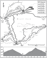
At 4.8 miles, ignore a lesser trail on the left. After noodling through a thick stand of fir, reach a fork at Eightmile Meadow, 5.7 miles, and turn left. The trail crosses a dirt road right at a fork—keep going until you find the trail on the opposite side. From here, the trail, rough in places, climbs to a high point,then rips down a hillside. At 6.9 miles, cross a paved road (FR 2730). At 7.2 miles (ridepoint 3), reach a T at Fifteenmile Campground and turn left. The trail follows Fifteenmile Creek on Trail 456. When the trail forks at 7.7 miles, take a sharp right on Cedar Creek Trail 457, and drop down to cross a bridge. After a short climb away from the creek, follow the bouncing singletrack, tricky in spots, as it descends and corkscrews (with a couple short middle-ring climbs) from a mixed stand of fir and pine down through an open forest of scattered ponderosa pine.
At 10.9 miles, the trail crosses a doubletrack and continues down. From the 11.7-mile point, the trail is gnarled—loose, rocky, and very steep. At 12.4 miles (ridepoint 4), reach the ride’s low point when you cross Fifteenmile Creek. Immediately reach a T and turn left. After about 14 miles, the trail seems to head straight up, gaining huge chunks of elevation. It’s a probable hike-a-bike. Woof! By 16.8 miles, the suffering is largely over, as the trail winds across an open, rocky hillside. Reach a fork in the trail at 17.6 miles and stay to the right.
At 18.1 miles (ridepoint 3), arrive back at Fifteenmile Campground.
From the campground, pedal up to the paved road and turn right. After a
short ascent, turn left onto an unmarked and not-so-maintained dirt road. The road heads west, climbing, and it’s kind of a grunt. At 19.5 miles, reach a T at another dirt road (FR 4420) and turn left. The ascent continues. At 20.1 miles, the dirt road ends in a berm. From here, FR 4420 has been converted to trail. Continue on. At 20.9 miles (ridepoint 5), find Trail 450 on the right. Take it, but not before putting on an extra layer.
The descent down Trail 450 is all joy and no pain. There’s no need for six inches of travel or body armor, but it’s fast and fun. Cross a couple of dirt roads.At 22.3 miles, reach a fork and bear left, continuing down Trail 450. At 24.5 miles (ridepoint 2), after an optional rock drop, you’ll pop out at FR 44. Cross the road and find Trail 459 immediately on the right. The smiles and tears continue as you hurtle down the smooth trail. At 27 miles, reach a four-way and turn right. Immediately cross a dirt road. From here, the trail switchbacks down to Eightmile Crossing Campground to complete the trip, 27.5 miles.
Gazetteer
Nearby camping: Fifteenmile Creek (primitive), Pebble Ford (primitive)
Nearest food, drink, services: Parkdale, Hood River
Distance: 27.5-mile amoeba
Route: Awesome singletrack descent, some dirt road
Climbs: Nasty and tough; high point: 5,720 ft,
gain: 2,920 ft
Duration: Fitness rider: 3 to 5 hours;
scenery rider: 5 to 8 hours
Travel: Hood River—37 miles; Portland—80 miles
Skill: Advanced
Season: Summer, fall
Map: Green Trails: Flag Point, Mount Hood
Rules: National Forest Recreation Pass required
Manager: Mount Hood National Forest,
Barlow District, 541-467-2291
Link: Mt Hood Recreation
Who will like this ride: You like to work for your descents, and be richly rewarded.